Tom Harrison: Yosemite High Country 2012

【旅行】有料アプリランキング
【旅行】総合ランキング
【AppStore総合】有料アプリランキング

旅行
ナビゲーション
2012-05-17
¥300
2.0.0
約96MB
International Mapping
International Mapping
アプリスクリーンショット


アプリ詳細
Tom Harrison Maps has produced high-quality California hiking trail maps for a number of years now. To reach a new wave of technologically savvy outdoor enthusiasts, Tom Harrison Maps teamed up with International Mapping to adapt their trail map series for the iPhone and iPad. International Mapping has surrounded their maps with a variety of easy-to-use navigational tools and personal customization features to help make your outdoor experience more enjoyable and memorable.
Yosemite High Country, in central California, is one of the most visited Parks in the United States. In 1984, this area was designated as a World Heritage Site with close to 95% of it being designated as wilderness. Filled with granite cliffs, waterfalls, clear streams, and Giant Sequoia groves, outdoor enthusiasts have been flocking to experience this place first hand. Planning a hike in the Yosemite High Country? Looking for an app to help you navigate all of the trails? Worried you will not have Wi-Fi access while out on the trail? Then this is the app for you as we have included everything you will need in the download!
Key Content Features:
+ Full content and detail from Tom Harrison’s Yosemite High Country map covering Merced Lake, Wawona, Ten Lakes, Tuolumne Meadows, Tioga Pass, Vogelsang, Bridalveil Creek, Hall Research Natural Area, and many more places of interest.
+ Point of Interest listings for over 500 locations in and around the Yosemite High Country Area
Key Features Include:
+ GPS tracking of your location, even without Wi-Fi or cell reception
+ A revolutionary new trail navigation system
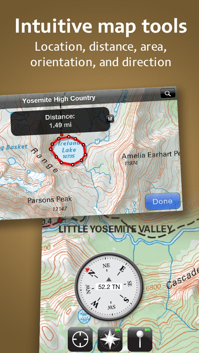
+ Map tools including distance, area, bearing and compass
+ Customized pins to record photos, comments, & locations along your hike
+ Share your custom markers with others who have the app
+ Customize your markers to change their appearance
+ Detailed search capabilities by nearby locations and by type
+ Identify the Latitude/Longitude or UTM Coordinate for any place on the map
Tom Harrison: Yosemite High Country was developed by International Mapping. To learn more visit: www.internationalmapping.com
対応端末
iPadFourthGen / iPad3G / iPodTouchThirdGen / iPadMini4G / iPadFourthGen4G / iPodTouchourthGen / iPhone5 / iPhone-3GS / iPhone4S / iPodTouchFifthGen / iPhone4 / iPad23G / iPadThirdGen4G / iPadWifi / iPadMini / iPhone5s / iPhone5c / iPad2Wifi / iPadThirdGen
リリースノート|新機能
+ Redesigned User Interface
+ Updated map content


Tom Harrison: Yosemite High Country 2012
ランキング解析情報詳細
【旅行】有料アプリ部門ランキング
2012-05-17
4366日経過
0回/366回
0回/366回
0回/366回
※当データはiOS-App.jpの独自集計によるものとなりAppStoreに実際に表示された内容と若干異なる場合がございます。