Tom Harrison: Mono Divide High Country 2012

【ナビゲーション】有料アプリランキング
【ナビゲーション】総合ランキング
【AppStore総合】有料アプリランキング

ナビゲーション
旅行
2012-11-20
¥300
1.0.0
約94MB
International Mapping
International Mapping
アプリスクリーンショット


アプリ詳細
Tom Harrison Maps has produced high-quality California hiking trail maps for a number of years now. To reach a new wave of technologically savvy outdoor enthusiasts, Tom Harrison Maps teamed up with International Mapping to adapt their trail map series for the iPhone and iPad. International Mapping has surrounded their maps with a variety of easy-to-use navigational tools and personal customization features to help make your outdoor experience more enjoyable and memorable.
California’s Mono Divide High Country covers portions of John Muir Wilderness, Ansel Adams Wilderness and Dinkey Lakes Wilderness area accessed from Bishop Pass-area and Rock Creek Trailheads on the east side, plus Florence and Edison Lakes on the west side, plus Pine Creek, Piute Pass, Silver Pass, and the Mono Hot Springs. Planning a hike in the Mono Divide High Country? Looking for an app to help you navigate all of the trails? Worried you will not have Wi-Fi access while out on the trail? Then this is the app for you as we have included everything you will need in the download!
Key Content Features:
+ Full content and detail from Tom Harrison’s Mono Divide High Country map covering Piute Pass, Silver Pass, Pine Creek, Rock Creek, South Lake, Goodale Pass, Florence Lake, North Lake, Lake Edison, and Mono Hot Springs.
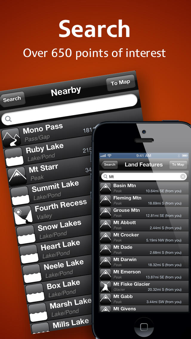
+ Point of Interest listings for over 500 locations in and around the Mono Divide High Country Area
Key Features Include:
+ GPS tracking of your location, even without Wi-Fi or cell reception
+ A revolutionary new trail navigation system
+ Map tools including distance, area, bearing and compass
+ Customized pins to record photos, comments, & Locations along your hike
+ Share your custom markers with others who have the app
+ Customize your markers to change their appearance
+ Detailed search capabilities by nearby locations and by type
+ Identify the Latitude/Longitude or UTM Coordinate for any place on the map
Tom Harrison: Mono Divide High Country was developed by International Mapping. To learn more visit: www.internationalmapping.com
対応端末
iPad3G / iPad2Wifi / iPodTouchThirdGen / iPodTouchourthGen / iPhone4 / iPadFourthGen / iPadMini / iPadWifi / iPhone4S / iPadThirdGen4G / iPhone5 / iPodTouchFifthGen / iPadFourthGen4G / iPhone5c / iPadMini4G / iPhone5s / iPad23G / iPhone-3GS / iPadThirdGen
リリースノート|新機能


Tom Harrison: Mono Divide High Country 2012
ランキング解析情報詳細
【ナビゲーション】有料アプリ部門ランキング
2012-11-20
4179日経過
0回/366回
0回/366回
0回/366回
※当データはiOS-App.jpの独自集計によるものとなりAppStoreに実際に表示された内容と若干異なる場合がございます。